


iNavX
Marine Navigation
Beschrijving van iNavX: Marine Navigation
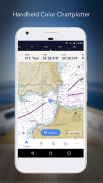
Navigatie op zee wordt gemakkelijk gemaakt met iNavX - 's werelds #1 handheld kaartplotter. Toegang tot zeekaarten, kaarten, weer, AIS en meer!
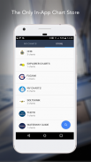
iNavX is de enige app die u volledige wereldwijde kaartdekking geeft, van al uw favoriete kaartaanbieders, inclusief de GLOEDNIEUWE iNavX Professional+ Global Chart! Volledig ingeschakeld met one-touch toegang, geeft iNavX gebruikers toegang tot de breedste set van zeekaarten en kaarten van meerdere providers, waaronder:
• iNavX Professional+-kaarten
• Blauwe breedtegraad
• Verkenner
• Ze zijn weer
• Waterweggids
• … en meer
Hoe tilt iNavX handheld nautische navigatie naar een hoger niveau?
• Zeilers - Plan vaarroutes met waypoint- en routebeheer. Krijg proactief zeilbeheer met GRIB-weersvoorspellingen en houd de wacht met AIS-overlays en integratie met uw systemen aan boord. Bovendien kunt u uw geweldige zeillocaties onthouden door foto's te geotaggen.
• Watersporters - Blijf op de hoogte van de vaaromstandigheden met voorspellingen met stromingen, wind en deining. Beheer uw vaaruitrusting met integratie van nautische instrumenten en sla geweldige vaarroutes op om te delen met het tracklog.
• Vissers - Ontdek nieuwe visplekken door gaten en inhammen te verkennen. Lokaliseer de beste visomstandigheden door koude fronten te identificeren en bewaar uw beste visplekken met onbeperkte markeringen.
Geavanceerde functies - iNavX is de app met de meeste functies die beschikbaar is voor alle zeil- en vaarbehoeften voor een geweldige prijs:
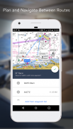
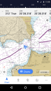
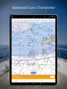
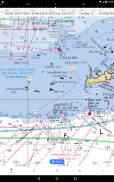
Geavanceerde kaartplotter
• Plot uw positie in realtime met behulp van de ingebouwde GPS van uw apparaat
• Kaarten pannen, zoomen en roteren (inclusief koers omhoog)
• Print gedetailleerde grafieken om te gebruiken in combinatie met de app
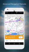
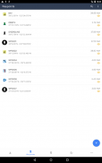
Geavanceerde navigatie
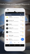
• Waypoints maken en routes plannen om ertussen te navigeren
• Tracklog stelt u in staat uw route vast te leggen
• Gegevens importeren/exporteren in KML (Google Earth) of GPX-indeling
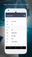
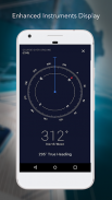
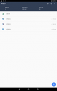
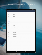
Geavanceerde Instrumentatie
• Ondersteunt NMEA-gegevens via TCP/IP (via Wifi)
• Integreert met externe GPS, AIS-ontvangers en transponders
• Sluit nautische instrumenten aan: diepte, snelheid, wind, motor, batterijen, enz.
Essentiële toolkit
• GRIB weersvoorspelling
• Getijden/stromingen
• Ankeralarm
• AIS-integratie
• Zoeken naar haven/navigatie
Download iNavX VANDAAG en ontvang automatisch een gratis exemplaar van de officiële en up-to-date hoge resolutie NOAA RNC Marine rasterkaarten van de Verenigde Staten.
BEOORDELINGEN
"iNavX is het origineel en nog steeds een van de beste navigatie-apps."
– Praktische zeeman
"De meest complete navigatie-app die er is en door velen als de standaard wordt beschouwd"
– Zeilmagazine
"De #1 aanbevolen app voor zeekaarten"
- iMarineApps
iNavX is compatibel met: C-MAP, Theyr Weather, Waterway Guide, AIS, Brookhouse, DigitalYacht, ShipModul, vYacht, Vesper Marine, NMEA 2000, Chetco en meer.
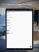
NIEUWE KAART WINKEL
Koop al je favoriete grafieken. Kaartabonnementen variëren per kaart en provider van $ 9,99 tot $ 199,99 per jaar, in rekening gebracht op je iTunes-account, die automatisch wordt verlengd, tenzij ten minste 24 uur voor het einde van de huidige periode wordt geannuleerd. Automatisch verlengen kan op elk moment worden uitgeschakeld door na aankoop naar je accountinstellingen in iTunes te gaan. Tijdens de actieve abonnementsperiode is opzegging van het huidige abonnement niet toegestaan.
OPMERKING: Voortgezet gebruik van GPS op de achtergrond kan de levensduur van de batterij aanzienlijk verkorten.
MEER INFORMATIE
Website: http://inavx.com/
Gebruikershandleiding: http://inavx.com/help/
Gebruiksvoorwaarden: http://inavx.com/terms
Privacybeleid: http://inavx.com/privacy
iNavX: Marine Navigation - versie 1.6.6
(03-08-2024)iNavX: Marine Navigation - APK-informatie
APK-versie: 1.6.6Pakket: com.gpsnavx.iNavXNieuwste versie van iNavX: Marine Navigation
Andere versies


Apps in dezelfde categorie

Mogelijk vind je dit ook leuk...


